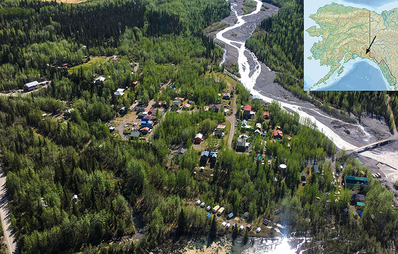
 McCarthy & Wrangell St. Elias Nat’l Park
The McCarthy PAMX area–Wrangell St. Elias Nat’l Park– is one of my all time favorite locations in Alaska. I believe this location and the general vicinity has the most stunning, absolutely breathtaking, scenery in all of Alaska.
A collection of pictures here.
YouTube Park Scenery Overview
As part of a weekly webinar series sponsored by supercub.org, I did a presentation covering scenery and related information when flying around Wrangell St Elias Nat’l Park. You can view the YouTube presentation at this link.
Scenery & History
Flying: See Wrangell St Elias Nat’l Park by Air (National Park information) (link)
All manner of flora and every variety of Alaskan animals. For instance, you’ll find glaciers, icefalls, huge mountains and stunning vistas.
There is intriguing history. As an example, Alaskan natives played a key role in the early development of this region. Furthermore, mineral exploration (and exploitation) for copper and gold were pivotal to early settlement.
Big !
Superlatives abound here: The largest U.S. Nat’l Park (map). 9 of the 16 highest peaks in N. America. Longest non-polar valley glacier (Nabesna Glacier). Largest non-polar piedmont glacier (Malaspina Glacier pic). Second largest icefield in N America (Bagley Icefield pic). The largest World Heritage Site in the world (Wrangell St Elias, Glacier Bay, Tatshenshini & Kluane Park [link]), Second highest icefall in the world (Stairway icefall pic),
Activities
You have lots of hiking, rafting and local tours to keep you occupied when you’re not flying. Link to Park Service authorized service providers. Lots of info on backcountry hikes/drop-off points: Expeditions Alaska, Kennicott Guides, St. Elias Alpine Guides, Trek Alaska,
Food & Lodging
There is an excellent saloon/restaurant (link & link). Also there is an outstanding bistro (my favorite; link). Great lunches, ice cream and snacks are available thru a food truck (link) (as of 2019).
Lodging options include camping, motel (link), lodges (link; link), and private cabins for rent. There is at least one bed-n-breakfast (link). McCarthy is becoming increasingly popular destination–each year seems to offer new food and lodging options.
Moose walks thru town: Only in McCarthy! https://www.youtube.com/watch?v=MQdUO6-xwSk
The Ultimate Fly-In Lodge
There is an upscale lodge outside of McCarthy itself–Ultima Thule (link). They showcase stunning YouTube videos of the area (link). Their YouTube channel offers a host of excellent scenic teasers showcasing what you will see flying around this region. I highly encourage you to invest time viewing their outstanding videos.
Other Videos and Attractions
Another long-time local pilot, Gary Green, also has a number of great YouTube videos of the local area. Well worth your time to view these (link)! Each year seems to bring more food & lodging options to the region. Do your homework prior to arrival.
Local McCarthy Airstrip(s) and 100LL
There are a somewhat confusing number of airstrips in the McCarthy area. The “main” so to speak, public strip PAMX is actually owned by the State. Self-serve fuel is NO LONGER available at PAMX. You can camp at PAMX. NO WATER. Get water at town at the Saloon restaurant, one of the hotels or at The Potato restaurant. There are two outhouses at PAMX.
Turbine twins occasionally land at PAMX as well as high-end singles (e.g. Cirrus). Tie-down locations are available (W side of the runway; Middle section). You can camp by your plane (no water–get some in town). Two outhouse facilities on the field. About a mile walk to town. There is the occasional shuttle van carrying passengers for the local flight-tour operator. You might be able to catch a ride for a small fee.
There is an active flight tour/charter operator on the town end of the field (Wrangell Mtn Air…link). Be alert for their position & pattern radio calls on 122.9. They operate a combination of C-172, C-206, C-185 and at least one Beaver aircraft.
You can, by prior arrangement, get fuel at OAK8 or “Fireweed” as it is known…call 907-554-4498 & get your credit card on file for fuel access/instructions. Fuel is located at the N end; at the end of runway 02. There is no camping allowed at Fireweed AFAIK. Long walk to restaurants/town from Fireweed. Get fuel and then fly over to PAMX for activities, hiking, tours, et cetera.
Other Airstrips
A number of charted strips exist in the greater area around McCarthy, both in and just outside Wrangell St Elias Nat’l Park. A few of the airstrips are on regional topographic charts. Several are shown on Park Service info sheets (link & link). Also a select few on the published VFR sectional for the area. For instance, the popular Jakes Bar AK0 (AK ‘zero’) and Glacier Creek KGZ).
A few of the backcountry strips are, at least in my opinion, becoming over-used. Too popular for their own good. Unstainable in a wilderness context For example Skolai Pass and Iceberg Lake
Wilderness is Precious!
Routes to the McCarthy Area
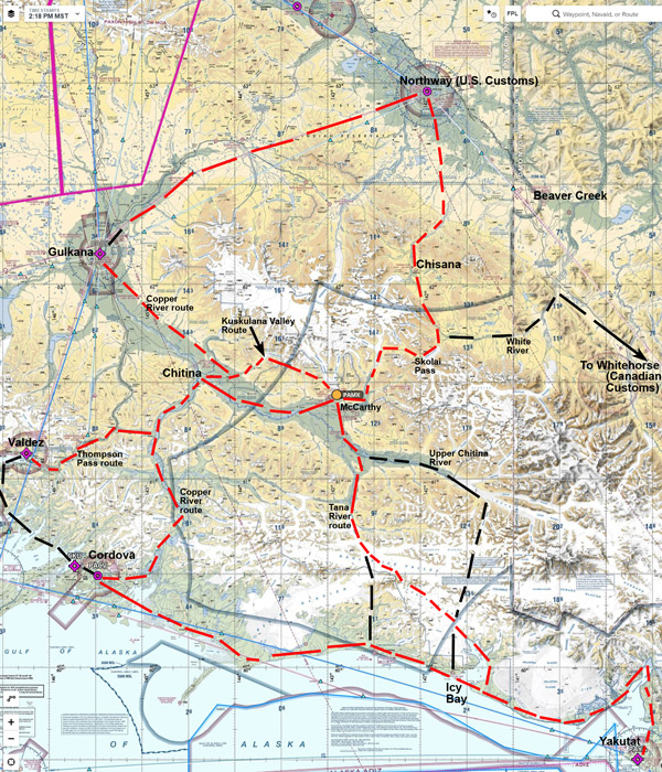
There are numerous ways to gain access to McCarthy PAMX. Only from an airplane can one hope to gain some perspective on the vast beauty found in the region. Here is a link to a larger version of the McCarthy Route map.
Checking Local Weather
No aviation weather reporting stations exist other than at Gulkana. There are weather cams (FAA–link; Copper Valley Telecom link. Note the “Sites” dropdown link toward the top right). Take a few minutes to view these prior to launching. I make note of weather specifics below on each route.
The closest public weather station is Chitina link
Route Map Comments
If you’re following the Alaska Hwy route, you will likely clear customs in Northway. From there you can follow the road to Gulkana (self-serve fuel). From PAKT on to Chitina CXC (pic) (no service) and into McCarthy PAMX.
Alternatively from Northway, you can follow the very scenic Chisana River. Good weather is required as Skolai Pass can sock in.
From Skolai Pass (airstrip pic) proceed by Chimney Peak (pic) then down the Nizina Glacier (pic). Then pass the spectacular Mile High cliffs (pic). Next a real treat: around the corner past the Sourdough Peak rock glacier (link). Then into McCarthy over Sourdough Ridge.
Gulkana To McCarthy
Another way into the McCarthy area is thru Gulkana PAGK. FAA weather cam at Gulkana (link). Self-serve fuel there. Easy route along the Copper River valley past Chitina CXC (pic) then to McCarthy.
Alternate Route Kuskulana Valley
Weather permitting, an alternate scenic valley route from Chitina turns up the Kuskulana valley (river/glacier name is on your sectional). Head over Kuskulana Pass (about 6,200′ easily clears the pass), along the scenic Kuskulana then Lakina Valley (pic). Finally head over 4th-of-July pass (link) into McCarthy. This is a popular scenic route for Wrangell Mtn Air. Look & listen 122.9 for traffic! Winds can sometimes be a real issue through the Chitina valley. If you see dust clouds ahead give it a second thought before proceeding past Chitina.
Valdez to McCarthy
From the Valdez area, you have several options, but generally fly over Thompson Pass as shown on the route map. Pictures here of the route. There is an FAA camera showing the current weather at Thompson Pass (link). Check if there is any doubt regarding conditions as Thompson Pass is a weather choke point.
Cordova to McCarthy
From Cordova the Copper River valley is an excellent low-weather route to the interior & McCarthy. One passes numerous glaciers. Beautiful flight. A few pictures of the route along the way here. Of course, if the weather cooperates there are several alternate scenic options available to fly-direct or sightsee along the way.
For instance, twice I followed the Bremner River (link), then the Little Bremner River up to Tebay Lakes (backcountry strip). I’m told there is ecellent fishing in the Tebay Lakes. From Tebay Lakes follow along the Tebay River thence to the Chitina river.
Yakutat Bay or Icy Bay to McCarthy
From Yakutat or Icy Bay, there are several options as shown on the route map. These options are highly weather dependent, as they are over seriously remote terrain. Nonetheless, both Wrangell Mtn Air & Ultima Thule pilots regularly fly these routes in good weather. No reason you too shouldn’t experience the wonder of the vast glaciers and stunning mountains (monitor 122.9)!
I’ve flown these and other route variations over the Guyot Glacier & Bagley Icefield many times. Study your charts, plan your own custom route, get up to about 8,000′ and enjoy the otherworldly vistas! Once past the Bagley Icefield area, there are numerous backcountry drop-off points. Stay alert for the occasional C-185, Super Cub or Beaver.
Departing McCarthy for Canada
One last path marked on the route map is if you find yourself departing McCarthy for Canada and points South. You can file for Canadian Customs at Whitehorse, and depart McCarthy out the very broad White River valley to the Alaska Hwy near Pickhandle Lake (Shakwak Trench link). Plenty of gravel bars to set down on along this route if needed.