Northway onward
Closest fuel from Northway is Tok PFTO or Gulkana PAGK (both self-serve). Lots of Special Use Airspace (SUA)–(See the “Flying in Alaska” set of links here: (Special Use Airspace)
Weather Changes Fast
In Northway, or prior, access the FAA Alaska cams (link) for current weather.
Similarly, there are other weather and informational flight planning websites on the “Links” page.
With any weather in the area, Tahneta Pass toward Anchorage quickly goes below minimums. For example, check the Sheep Mountain cam and talk to Flight Service.
Prior to Anchorage, review the Part 93 Chart Supplement (link).
Alaska Designated Common Traffic Advisory Frequency Areas
Excellent PDF on the development and operational considerations of special frequency areas within Alaska. Link here.
Military Special Use Airspace in Alaska
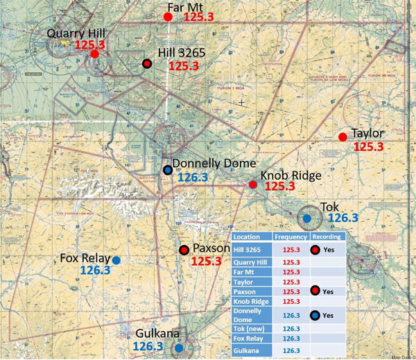
This map shows frequencies for SUA status. More information below. Link to larger image.
Fairbanks Area
The Fairbanks area has lots of military airspace and civilian traffic. Study Part 93 (link) and other below docs prior to arrival. For example:
- Fairbanks Pilot Bulletin. Helpful information on weather, special use airspace, runway safety, etc link
- Air Force SUA data. Good PDF with maps, frequencies, and phone numbers (link). Also reference data on MOAs and Restricted Airspace in central Alaska.
AOPA encourages pilots to use the SUA Information Service. Active use encourages the AF to expand this resource in other areas.
Anchorage Area
Anchorage also has high-density military and civilian traffic. Check FAR Part 93 (link) for helpful information. Joint Base Elmendorf-Richardson provides additional military info (See the “Flying in Alaska” set of links here: (Special Use Airspace).
Furthermore, special regional CTAF frequencies exist. For instance, see Matanuska Susitna Valley info (link). AOPA works closely with local pilot groups regarding issues in these high density traffic areas. Background information here.