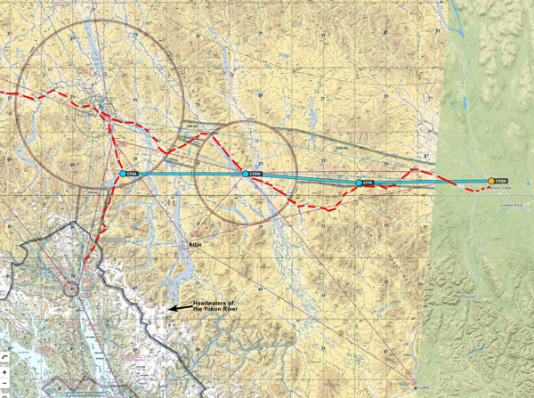
Watson Lake to Carcross/Skagway
This flight, though relatively short, encompasses a number of options.
Large trip route map link.
Watson Lake Comments
Watson Lake (pictures link) has self-service fuel. The FBO is manned perhaps 18+ hours/day. There is good WiFi and a phone to call Flight Service if you don’t want to use your cell phone.
The last two or three times thru Watson Lake it seemed to me that their radio transmissions were both weak and fraught with interference. Everywhere else was clear–so it wasn’t my plane. For what it’s worth, I couldn’t get a hold of the field until I was within 5 to certainly less than 10 miles.
Do not land on the abandoned runway! Big tire planes are able to use grass–don’t announce such. Simply land on the grass adjacent to the main runway and taxi in on the main runway. As always, use the grass at your own risk. As of late May 2022 there is NO water at Watson Lake. Used to be able to pump water by the gazebo. Perhaps they simply have not turned on the pump/water after winter yet; Perhaps it is permanently out of service. No water reported in the terminal building either. Here is an image of where the Gazebo is for camping.
Watson Lake History
Inside the FBO there are a lot of historical pictures from when Watson Lake was a major hub on the WW-II Lend Lease aircraft route from the U.S. to Russia. Links to history here and here. The person operating the radio(s) isn’t (their own words) a “weather person.” If you want any weather information you have to use the phone to call Canadian flight service folks (# on the wall by the phone–free call of course).
The original WW-II (massive) hangar (pictures link) is neat to see–Note: You cannot enter the hangar! Even though the door was open when we were last there, the folks working inside were decidedly unfriendly and absolutely emphatic that we not cross the hangar door threshold.
Camping is available with water at the gazebo SW of the terminal building. On arrival or departure, if you look closely, there are still the remains of a WW-II bomber on the far S shore underwater that crashed on takeoff from the now decommissioned N-S runway.
Watson Lake Onward
Link here to weather cameras in the Yukon. Very helpful for flight planning. Might have to scroll down to see the Yukon list.
From Watson Lake I highly recommend you proceed along Hwy 1 along the Swift River. You’ll pass the Pine Lake grass strip (CFY5), continuing toward Teslin then into Carcross. Pictures traveling from Watson Lake to Carcross (link). Looking at the map, you can go direct, or follow the 2-lane road out of Watson Lake.
There is a high point (about 3,400′) near Pine Lake airfield (3,250′) where clouds can stack up during any weather. Since there are no weather reporting stations other than at Watson Lake or Whitehorse sometimes you just have to carefully take a look yourself.
Teslin
Teslin has a gravel runway (no services). This is a key decision point. Proceed along the hwy to Whitehorse or head over more or less direct to Carcross (about 56 nm).
Scenic Option
Along the way to Carcross, or even later on a separate day out of Carcross, you might want to fly S to check out the headwaters of the Yukon River at the Llewellyn Glacier at the bottom end of Atlin Lake. One time I flew direct from Watson Lake to the LLewellyn Glacier–quite remote territory for sure. A few remote cabins by lakes (floatplane access only). Pretty scenery!
Atlin
Atlin has a long gravel runway, but no fuel and no water with perhaps a long mile+ walk into town. No cell service; No WiFi. Not a recommended stop unless you simply want to stretch your legs.
Carcross–Great Stop
Image of where parking/tiedowns are at Carcross.
Carcross is one of my favorite stops on the entire trip. Ed & Dorothy at the gravel strip are very friendly. The camping is comfortable (no facilities). The bistro (link) has excellent beer & food. The coffee shop is awesome. Regular breakfast options in the gas station restaurant. Good WiFi in that area.
Some years a visit doesn’t work out due to weather (e.g. 2019). But if you get to Watson Lake heading this way is highly recommended! As far as I know, as of 2019, there are no motel/hotels there. Rumor has it the original Caribou Hotel in Carcross is being remodeled, but I haven’t been able to confirm that yet.
Carcross To Skagway
From Carcross (to Skagway) you can either follow the road (shown in red on the linked map) or along Lake Bennett, then over the Chilkoot Pass trail as followed by the aspiring miners in the Yukon/Klondike gold rush of 1898. Lots of history along the Chilkoot trail.
Skagway is a very high density traffic area. Multiple sightseeing and helicopter operations. Excellent maps and discussions on special flight routes in the greater Skagway area here. Please review!